UP NOAH APK
Download UP NOAH APK for android
The description of UP NOAH
Monitoring weather disturbances, and their corresponding hazards, has now been made easier.
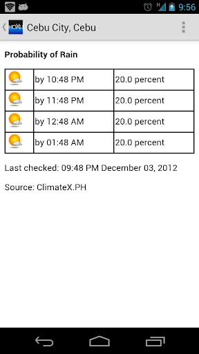
• Get updates on rain and weather outlooks for different Philippine cities
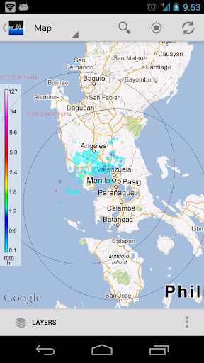
• View satellite images of typhoons in the Philippine Area of Responsibility
• See actual and forecasted typhoon positions
• Check water levels of streams all over the country
• View recorded rainfall amounts in the past 24 hours
• See areas with possible flooding and landslides due to heavy rain
• Share NOAH's information easily to your social media accounts
This is the official Android version of the University of the Philippines Nationwide Operational Assessment of Hazards (UP NOAH) website (http://noah.up.edu.ph). The companion app to ARKO (the mobile app for flood, storm surge, and landslide hazard maps), the NOAH Android app features a user-friendly interface that allows you to view near real time weather information, which can help prevent and mitigate disasters.
This mobile app was developed by Rolly Rulete in cooperation with UP NOAH, with the partnership of Smart Communications, Inc. through the Smart Developer Network (SMART DevNet). Content and data come from the Department of Science and Technology (DOST) and its participating agencies.
UP NOAH’s mission is to undertake disaster science research and development, advance the use of cutting edge technologies and recommend innovative information services in government's disaster prevention and mitigation efforts. Though the use of science and technology and in partnership with the academe and other stakeholders, the DOST through Program NOAH is taking a multi-disciplinary approach in developing systems, tools, and other technologies that could be operationalized by government to help prevent and mitigate disasters.
FEATURES:
Layers
1) Philippine Area of Responsibility (PAR)
2) Overview
– GSMAP
– HIMAWARI
– HIMAWARI Transparent
– Rainfall Contour
– 3-hour Rainfall
– 6-hour Rainfall
– 12-hour Rainfall
– 24-hour Rainfall
– Temperature Contour
– MSL Pressure Contour
– Humidity Contour
– % Chance of Rain
3) Doppler
– Aparri Station
– Baler Station
– Subic Station
– Tagaytay Station
– Tagaytay Station (400km)
– Virac Station
– Cebu Station
– Cebu Station (400km)
– Hinatuan Station
4) Sensors
– Weather Stations
– Stream Gauges
– Rain Gauges
– Tide Levels
5) Weather Outlook
– Rain Forecast
– Weather Outlook
– PAGASA Cyclone Update
* switchable between two base maps (Google Satellite and Google Maps)
* plus status notifications for "Probability of Rain"
* share screenshot (in almost all views) or text contents (News) via applications (Facebook, Twitter, Instagram, Bluetooth, Gmail, etc)
* the app is themeable! (Holo Light [default theme] OR Holo Dark)
* supports animated overlays (HIMAWARI, Doppler, Chance of Rain)
* improved caching for performance and offline usage
* very flexible Settings
keywords: Project NOAH, DOST, PAGASA, NOAH, NDRRMC, nababaha, ClimateX, MMDA, SMART, SMART DevNet, University of the Philippines
Download UP NOAH APK for android direct link
What's new
2017-07-25
Slightly adjusted satellite image boundaries.
Get it on: